This article has been reviewed according to Science X's editorial process and policies. Editors have highlighted the following attributes while ensuring the content's credibility:
fact-checked
peer-reviewed publication
trusted source
proofread
Space lasers have unearthed plethora of climate data over the years

A team of scientists has sifted through two decades' worth of climate data collected by NASA laser pulses, and say it both paints a sobering picture and underscores the need for such missions to continue.
Published in Nature Reviews Earth & Environment, their paper synthesizes the most crucial findings—including the rate of melting ice caps—from three NASA satellite laser altimeter missions.
"Satellite laser altimeters accurately measure how the Earth's surface evolves on a global scale," says study co-author Beata Csatho, Ph.D., professor and associate chair of the University at Buffalo Department of Geology, within the College of Arts and Sciences.
"Repeat measurements could reveal even small changes in land, ice and water surface elevations, which is critical to understanding the processes driving those changes and their impact."
A satellite laser altimeter sends a laser beam pulse from space that illuminates a specific area on Earth and then bounces back. The topography—the height and shape—of an area can be determined by how far the laser travels and how long it takes to bounce back.
For the last few decades, these lasers have radically improved our understanding of critical climate issues, such as melting ice, sea level changes, carbon levels in forests and the amount of aerosols in the sky.
"We know from 20 years of observation that this is a great technology that can tell stories about our planet through data with unprecedented accuracy and resolution," says the study's lead author, Lori Magruder, Ph.D., associate professor in the University of Texas at Austin Department of Aerospace Engineering and Engineering Mechanics.
The team looked at data gathered from the original laser altimetry mission, Ice, Cloud and land Elevation Satellite (ICESat), which ran from 2003 to 2009, as well as the ICESat-2 and Global Ecosystems Dynamic Investigation (GEDI) missions, both of which launched in 2018 and remain active today.
Csatho served on NASA's science team for the ICESat and ICESat-2 missions, as well as Operation IceBridge. She led the Science Definition Team of ICESat-2 from 2011 to 2014.
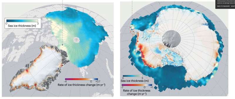
Collectively, the data from the three missions demonstrates the rapid changes that Earth has experienced in a relatively short amount of time. For example, Greenland and Antarctica lost a combined 320 gigatonnes per year in mass between 2003 and 2019, while the Arctic saw a 30% decrease in winter sea ice between 2003 and 2021.
"While our 20-year review reveals changes attributable to climate change, a more extended period of data is needed to identify trends and detect accelerating trends that could occur in the future, as we potentially reach a tipping point where changes become irreversible," Csatho says.
After ICESat-2 and GEDI, the United States has no further laser altimetry missions scheduled.
Every 10 years, the National Academies of Sciences, Engineering and Medicine publish the Decadal Survey for Earth Science and Applications from Space, which will help shape science priorities and guide agency investments into the next decade. The survey is driven by input from the scientific community and policy experts.
The next survey is in 2027 and will certainly play a role in the future of space missions and research.
More information: Lori A. Magruder et al, Monitoring Earth's climate variables with satellite laser altimetry, Nature Reviews Earth & Environment (2024). DOI: 10.1038/s43017-023-00508-8
Journal information: Nature Reviews Earth & Environment
Provided by University at Buffalo


