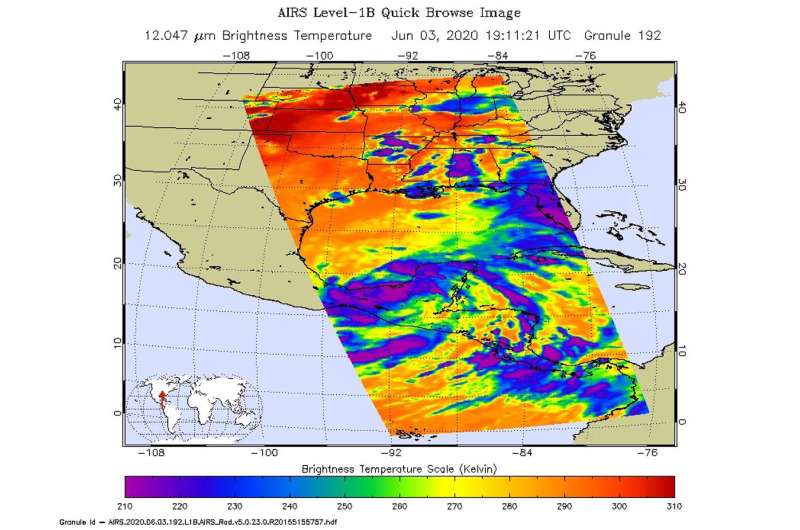
NASA infrared imagery indicates Cristobal's heavy rainmaking capabilities

One of the ways NASA observes tropical cyclones is by using infrared data that provides temperature information and indicates storm strength. The AIRS instrument aboard NASA's Aqua satellite gathered that data and revealed Cristobal has the potential to generate heavy rainfall. That rainfall is now soaking Mexico and portions of Central America as Cristobal meanders.
At 9:35 a.m. EDT on Wednesday, June 3, Tropical Storm Cristobal made landfall in the Mexican state over Campeche, just to the west of Ciudad del Carmen. At the time of landfall, maximum winds were estimated to be 60 mph (95 kph) with higher gusts. Since landfall, Cristobal weakened to a depression, and moved very slowly in a southeasterly direction into northwestern Guatemala. As the storm weakened, it expanded, now heavy rainfall is expected in Mexico, Guatemala, El Salvador, Belize and Honduras.
Damaging and deadly flooding has already been occurring in portions of Mexico and Central America. Cristobal is expected to produce additional extreme rainfall amounts through the end of the week.
Colder Cloud Top Temperatures Indicate Strength
Cloud top temperatures provide information to forecasters about where the strongest storms are located within a tropical cyclone. Tropical cyclones do not always have uniform strength, and some sides are stronger than others. The stronger the storms, the higher they extend into the troposphere, and the colder the cloud temperatures.
NASA provides this infrared data to forecasters at NOAA's National Hurricane Center (NHC) so they can incorporate in their forecasting. That data is reflected in the NHC forecasts of rainfall amounts.
On June 3 at 3:11 p.m. EDT (1911 UTC) NASA's Aqua satellite analyzed Tropical Storm Cristobal using the Atmospheric Infrared Sounder or AIRS instrument. AIRS found coldest cloud top temperatures as cold as or colder than minus 63 degrees Fahrenheit (minus 53 degrees Celsius) south and east of center, over Mexico's Yucatan Peninsula. NASA research has shown that cloud top temperatures that cold indicate strong storms that have the capability to create heavy rain.
A Look at Extreme Rainfall Potential
NHC forecasters using infrared and other satellite data noted that Cristobal is expected to produce high rain accumulations through Saturday, June 6. NHC noted,"The Mexican states of Campeche, Quintana Roo, Tabasco, and Yucatan are expected to receive an additional 6 to 12 inches, with isolated storm totals of 25 inches.
Mexican states of Veracruz and Oaxaca can expect an additional 5 to 10 inches, while southern Guatemala and parts of Chiapas can expect an additional 15 to 20 inches, and isolated storm total amounts of 35 inches dating back to Saturday, May 30. El Salvador can also expect an additional 10 to 15 inches, with isolated storm total amounts of 35 inches dating back to Saturday, May 30. In Belize and Honduras, an additional 3 to 6 inches with isolated amounts to 10 inches are forecast.
Rainfall in all of these areas may produce life-threatening flash floods and mudslides."
Cristobal on June 4, 2020
NOAA's National Hurricane Center updated Cristobal's status on June 4 at 11 a.m. EDT (1500 UTC) and noted that since it made landfall on June 3, it had weakened to a depression. The center of Tropical Depression Cristobal was located near latitude 17.6 degrees north and longitude 91.0 degrees west. That places the center of Cristobal about 160 miles (260 km) south-southwest of Campeche, Mexico.
The depression is moving toward the east-southeast near 3 mph (6 kph). The estimated minimum central pressure is 998 millibars. Maximum sustained winds have decreased to near 35 mph (55 kph) with higher gusts. Little change in strength is expected through tonight [June 4]. Re-intensification is expected to begin on Friday.
Cristobal's Forecast Path
Forecasters at the NHC said that Cristobal is expected to turn back into the Gulf of Mexico after moving over extreme northwestern Guatemala and eastern Mexico today and tonight. The center is forecast to move back over the southern Gulf of Mexico [June 5] Friday day or Friday night, over the central Gulf of Mexico on Saturday, and approach the northern Gulf of Mexico coast [June 7] Sunday day and Sunday night.
Provided by NASA's Goddard Space Flight Center


