NASA's GPM examines developing US severe weather

The Global Precipitation Measurement mission or GPM core satellite has been busy analyzing severe weather in the U.S.
Until May 1, tornado alley was experiencing a drought of spring tornadoes. The eighteen tornadoes reported in the area yesterday may be a sign of things to come. Moisture laden air from the Gulf of Mexico is having a more normal interaction with dry air flowing from the desert south-western states (dry line). Wind speed and wind direction change (shear) with height results in thunderstorms that spawn rotation and tornadoes.
The GPM core observatory satellite passed over tornado alley in the early morning of May 1, 2018, at 6:28 a.m. CDT (11:38 UTC). Tornadoes were not observed until the afternoon but storms were already shown firing up from Kansas to Minnesota. The GPM's satellite's Microwave Imager (GMI) and Dual Frequency Precipitation
Radar (DPR) instruments scanned this stormy area and provided instantaneous measurements of precipitation intensity. GPM's radar (DPR Ku Band) found that a few storms in Kansas were dropping rain at a rate of over 1.4 inches (35.6 mm) per hour.
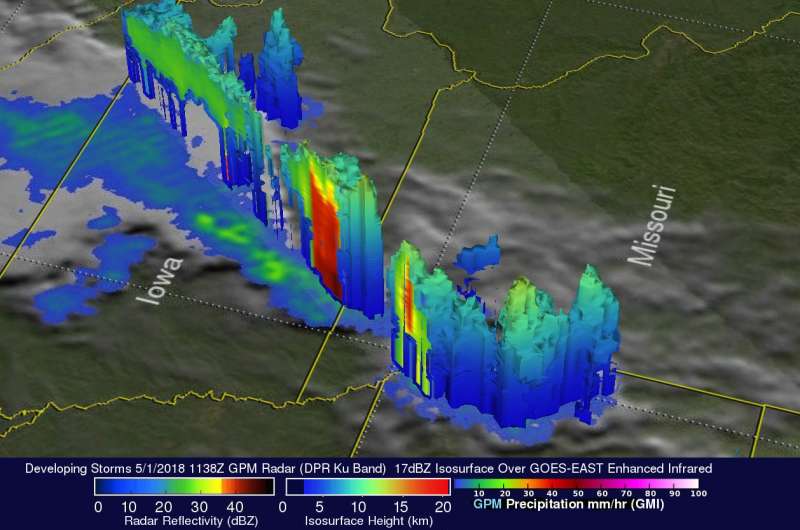
GPM's 3-D radar (DPR Ku Band) data obtained a view looking toward the northeast, and showed the 3-D structure of precipitation within those early morning storms. DPR cross-section scans showed that a few storm tops in northeastern Kansas were already reaching heights above 8.6 mile (13.9 km). In a graphic developed at NASA's Goddard Space Flight Center in Greenbelt, Maryland, a color enhanced vertical slice revealed that downpours over southwestern Iowa were returning strong radar reflectivity values exceeding 53.5 dBZ to the satellite.
GPM is a joint mission between NASA and the Japan Aerospace Exploration Agency, JAXA.
The National Weather Service forecast for the afternoon and evening of May 2 noted "Severe thunderstorms are expected across parts of the southern and central Plains into the middle Mississippi Valley this afternoon into tonight. Swaths of damaging winds, large to very large hail, and several tornadoes are anticipated, especially from western/central Oklahoma across southern to eastern Kansas and northern to central Missouri."
The National Weather Service Storm Prediction Center is forecasting "an Enhanced-to-Moderate Risk of severe weather for the Central and Southern Plains and into the Mid-Mississippi River Valley on Wednesday and Wednesday night [May 3]. Severe thunderstorms with damaging straight-line winds, large to very large hail, and a couple of tornadoes will be possible."
Provided by NASA's Goddard Space Flight Center


