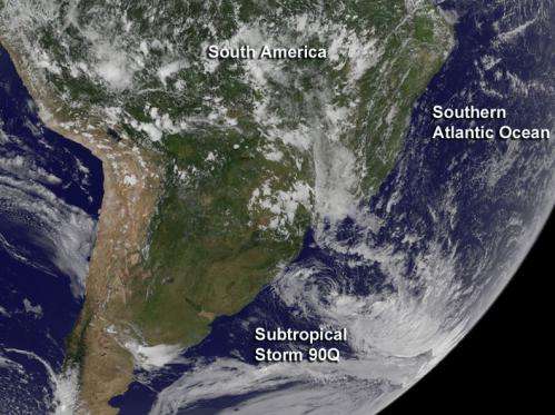
This GOES-East "full disk" view of the Atlantic Ocean from 17:45 UTC (1:45 p.m. EDT) on March 12 shows newborn sub-tropical cyclone 90Q. Credit: NASA/NOAA GOES Project
The Brazilian Navy Hydrographic Centre reported that a sub-tropical storm had formed on March 11 near east of the Brazilian state of Rio Grande do Sul, the southeastern most state in Brazil.
NOAA's GOES-East satellite provided imagery of the Atlantic that showed Subtropical Cyclone 90Q off the southeastern coast of Brazil at 17:45 UTC (1:45 p.m. EDT). The system appeared to have fragmented banding of thunderstorms around the low-level center. The image was created by NASA/NOAA's GOES Project at NASA's Goddard Space Flight Center in Greenbelt, Maryland.
At 1200 UTC (8 a.m. EDT) on March 12, the Brazilian Navy Hydrographic Centre (BNHC) noted that Sub-tropical storm 90Q was located near 32 degrees south latitude and 44 west longitude. 90Q's minimum central pressure was estimated near 1006 millibars. Maximum sustained winds were near 45 knots (51.7 mph/83.3 kph) and it was moving to the south-southeast at 5 knots (5.7 mph/9.2 kph). For more information, visit the BNHC website at: http://www.mar.mil.br/dhn/chm/meteo/prev/cartas/cartasing.htm
Provided by NASA's Goddard Space Flight Center


