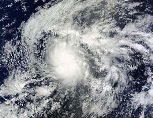
When NASA's Terra satellite passed Tropical Depression 1C on July 17 at 3:55 p.m. EDT, the storm and it appeared somewhat elongated. Credit: NASA Goddard MODIS Rapid Response Team
The first tropical cyclone of the season has formed in the Central Pacific Ocean as NASA's Terra satellite passed overhead. Tropical Storm Wali formed southeast of the Big Island of Hawaii, and now that it's nearing, a Flash Flood Watch has been posted for all of the islands.
NASA's Terra satellite passed over Wali on July 17 at 19:55 UTC (3:55 p.m. EDT) just as it was being classified as Tropical Depression 1C. NOAA's Central Pacific Hurricane Center (CPHC) issued an advisory at 5 p.m. EDT (11 a.m. HST) announcing the birth of the depression near 12.7 north and 140.7 west with maximum sustained winds near 35 mph (55 kph). When NASA's Terra satellite passed overhead, the Moderate Resolution Imaging Spectrometer (MODIS) took a visible picture of the storm and it appeared somewhat elongated.
One hour after its birth as a tropical depression (2200 UTC/6 p.m. EDT/12 p.m. HDT) Tropical Depression 1C became Tropical Storm Wali as maximum sustained winds ramped up to 45 mph (75 kph).
his animation of infrared and visible imagery from NOAA's GOES-West satellite from July 15 to 18 shows the birth of Tropical Storm Wali southeast of the Big Island of Hawaii on July 17. Credit: NASA/NOAA GOES Project
On July 18 at 0900 UTC (5 a.m. EDT/July 17 at 11 p.m. HST/) Tropical Storm Wali's maximum sustained winds remained near 45 mph (75 kph), and the CPHC noted that slight strengthening is possible for the next day before a weakening trend begins. Wali was located near latitude 14.1 north, longitude 141.6 west, about 970 miles (1,565 km) east-southeast of Hilo, Hawaii. Wali was moving toward the northwest near 12 mph (19 kph) and CPHC expects Wali to continue in that direction until it makes a slight turn toward the west on Saturday. The estimated minimum central pressure is 1003 millibars.
The National Weather Service (NWS) in Honolulu issued a Flash Flood Watch for the Hawaiian Islands from Saturday night (July 19) through Monday (July 21). The NWS noted "deep tropical moisture combined with an upper level trough will bring the threat of heavy rain and thunderstorms from Saturday night through Monday. Enhanced showers will reach the windward Big Island and Maui Saturday night, and the rest of the state Sunday."
The CPHC expects Wali to maintain tropical storm status until late Saturday, July 19, when it is expected to weaken to a depression. Increasing vertical wind shear, cooler sea surface temperatures and drier air that is expected to move into Wali are three factors that will contribute to weakening the storm as it approaches the Big Island. However, heavy rainfall is expected to affect the Hawaiian islands later this weekend as the current forecast track for Wali takes it on a path toward the Big Island of Hawaii late Sunday, July 20 or early Monday, July 21.
Provided by NASA's Goddard Space Flight Center


