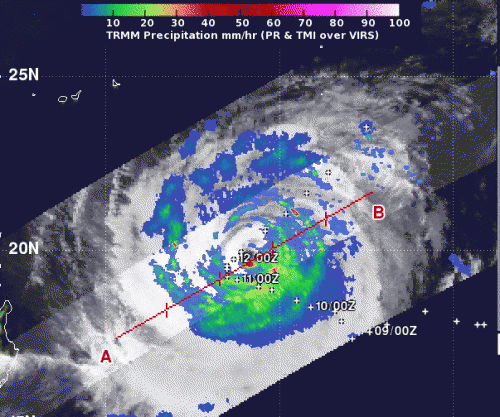
When NASA's TRMM satellite passed over Typhoon Prapiroon on Oct. 12 at 0741 UTC (3:41 a.m. EDT), light to moderate rainfall (blue and green) was occurring over most of the storm at a rate between .78 to 1.57 inches/20 to 40 mm per hour. There was a small area of heavy rainfall (red) just south of the center where rain was falling at 2 inches (50 mm) per hour. Credit: Credit: SSAI/NASA, Hal Pierce
NASA measured light-to-moderate rainfall occurring throughout Typhoon Prapiroon, with just a small area of heavy rain near the storm's center is it tracks through the western North Pacific Ocean.
When NASA's Tropical Rainfall Measuring Mission (TRMM) satellite passed over Typhoon Prapiroon on Oct. 12 at 0741 UTC (3:41 a.m. EDT), the precipitation radar instrument detected light to moderate rainfall occurring over most of the storm at a rate between .78 to 1.57 inches/20 to 40 mm per hour. The northwestern quadrant of the storm had the lightest rainfall rate.
There was a small area of heavy rainfall just south of the ragged eye where rain was falling at 2 inches (50 mm) per hour. TRMM also noticed that the highest thunderstorms were almost 12 kilometers (7.4 miles) high in that same region of heavy rain.
In addition to dropping a lot of rain, Typhoon Prapiroon is churning up the seas around it. The Joint Typhoon Warning Center noted that waves are as high as 41 feet (12.5 meters) in the vicinity of the storm.
At 1500 UTC (11 a.m. EDT) on Oct. 11, Typhoon Prapiroon's maximum sustained winds were near 90 knots (103 mph/166.7 kph). It was located near 20.3 North latitude and 129.4 East longitude, about 370 nautical miles (425.8 miles/685.2 km) south of Kadena Air Base, Okinawa, Japan. Prapiroon is moving to the east-northeast at 4 knots (4.6 mph/7.4 kph) and is expected to continue moving over open ocean and in that general direction over the next couple of days.
Provided by NASA's Goddard Space Flight Center


