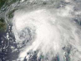
This visible image of Tropical Storm Debby spinning in the northeastern Gulf of Mexico was captured on Sunday, June 24 at 3:00 p.m. EDT from the MODIS instrument on NASA's Aqua satellite. Credit: NASA Goddard MODIS Rapid Response Team
Like a white blanket, Tropical Storm Debby's clouds covered the entire state of Florida in a NASA satellite image.
Two satellites have captured imagery that shows Tropical Storm Debby has thrown a large white blanket of clouds over the state of Florida, and it doesn't seem like that blanket is going to lift quickly as Debby moves slowly north.
NASA's Aqua satellite passed over Tropical Storm Debby and the Moderate Resolution Imaging Spectroradiometer (MODIS) instrument onboard the satellite captured a visible image of the storm on Sunday, June 24 at 3:00 p.m. EDT. The image clearly showed Debby's center over the northeastern Gulf of Mexico, and the bulk of the clouds, showers and thunderstorms wrapping from the north to the east to the south of the center of circulation and covering the entire state of Florida. The northern-most extent of Debby's clouds were over southern Alabama and south Georgia. Tropical-storm-force winds on June 25 extend outward up to 230 miles (370 km) mostly southeast of the center, and the imagery from MODIS shows that the cloud cover is most extensive in that direction.
On Monday, June 25, 2012 at 11 a.m. EDT, Debby's maximum sustained winds had dropped to 45 mph (75 kmh). It was located just 75 miles south of Apalachicola, Florida, near 28.6 North and 85.2 West. Debby was crawling to the north at 3 mph (6 kmh). Debby's minimum central pressure was 995 millibars.
An animation of satellite observations shows the progression of Tropical Storm Debby from June 23-25, 2012. The animation begins 12 hours after Debby became a tropical storm in the Gulf of Mexico, 225 hundred miles south-southeast of the mouth of the Mississippi River on June 23. This visualization was created by the NASA GOES Project at NASA Goddard Space Flight Center, Greenbelt, Md., using observations from NOAA's GOES-13 satellite. TRT :51. Credit: NASA/NOAA GOES Project
On June 25, 2012 at 11:45 a.m. EDT a visible satellite image of Debby captured by NOAA's GOES-13 satellite showed that the storm's clouds continued to blanket all of Florida. The image also showed that the bulk of Debby's clouds and showers continued to be from northeat to southeast of the center of circulation, which was still in the northeastern Gulf of Mexico. Both the GOES-13 and the MODIS satellite images were created at NASA's Goddard Space Flight Center in Greenbelt, Md.
The National Hurricane Center (NHC) noted that Debby is expected to continue crawling to the northeast or east-northeast over the next couple of days, bringing more soaking rains for the sunshine state. The NHC doesn't expect much change in intensity, however.
As a result of Debby's new more northerly track, some of the warnings and watches have been changed as of 11 a.m. on June 25. The tropical storm warning from the Florida-Alabama border to Destin, Fla. has been discontinued. In addition, the tropical storm watch from the Suwannee River to Englewood has been changed to a tropical storm warning. The tropical storm warning area now covers the Florida Gulf Coast from Destin to Englewood.
A quick look at watches and warnings in effect on Monday, June 25 for three western Florida cities tell the story of what Debby is doing to its residents. In Tampa, there is a Tropical Storm Warning, a Coastal Flood Warning, a Tornado Watch, a Flood Warning, a High Surf Advisory and a Flood Watch as a result of Debby. Further north in Pensacola, there is a High Surf Advisory and a Wind Advisory. South of Tampa in Fort Myers,there is a Tornado Watch, Coastal Flood Advisory, High Surf Advisory and Flood Watch.
Tropical-storm-force winds are expected to continue over portions of the Florida Gulf coast today. Heavy rainfall is a key concern today, after Florida was soaked yesterday from Debby. According to the NHC, northern and central Florida can see accumulations of 10 to 20 inches with as much as 25 inches. Southeastern Georgia and extreme South Carolina will also feel Debby's wet wrath, as totals between 5 and 15 inches are possible in both areas.
Storm surges are expected to range between one and five feet along the Gulf coast between Apalachee Bay to southeastern Louisiana. Isolated tornadoes are also a threat as they are with any landfalling tropical cyclone. Some are possible today across the eastern Florida panhandle, Florida peninsula and southern Georgia.
NASA's Kennedy Space Center on the Atlantic coast is included in a tornado watch for the area due to a line of thunderstorms approaching from the west. Elevated winds are expected throughout the day and for the next few days. Between one to three inches of rainfal are expected over the next day, and are likely to continue as Debby crawls northward.
Provided by NASA's Goddard Space Flight Center


