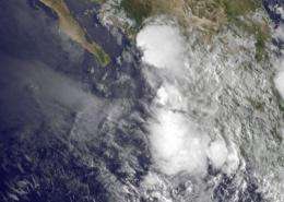
This GOES-11 image from Sept. 1 at 9:45 a.m. EDT shows the remnant clouds of Tropical Depression 8E as a rounded swirl of clouds hugging Mexico's southwestern coastline. The brighter white areas indicate higher, stronger thunderstorms. Credit: NASA/NOAA GOES Projec
An infrared satellite look at Tropical Depression 8E along the Mexican coast shows that the storm became more disorganized in the last 24 hours, and is now a remnant low pressure area.
Tropical Depression 08E (TD8E) has weakened to a remnant low pressure system over Mexico. TD 8E's remnants were raining on Manzanillo and Puerto Vallarta at 10 a.m. EDT (7 a.m. PDT) today and the bulk of the heavier rainfall was off-shore.
A NOAA GOES-11 satellite image from Sept. 1 at 9:45 a.m. EDT showed the remnant clouds of Tropical Depression 8E as a rounded swirl of clouds hugging Mexico's southwestern coastline. There were some higher, stronger thunderstorms visible in the infrared image that appeared whiter and brighter than the surrounding clouds. Those higher clouds were around the center of TD8E's circulation. The GOES-11 image was created by the NASA GOES Project at NASA's Goddard Space Flight Center, Greenbelt, Md.
The National Hurricane Center (NHC) issued their last warning for the remnants of TD8E at 11 p.m. EDT on August 31. At that time, it was about 130 miles (209 km) east-southeast of Cabo Corrientes, Mexico near 19.8 North and 103.8 West. Its maximum sustained winds were down to 20 knots (23 mph/37 kmh) and it was moving to the northwest at 10 knots (12 mph/19 kmh).
On the morning of Sept. 1, 2011, TD8E's remnants were still raining on the southwestern coast of Mexico. As much as 4 to 6 inches (10-15cm) of rain are expected over the coastal areas of the states of Guerrero, Michoacan and Colima.
The NHC noted that there's a low chance, just 10 percent, that TD8E will regenerate.
Provided by NASA's Goddard Space Flight Center


