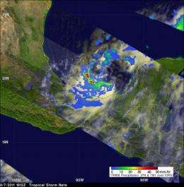
NASA's TRMM satellite flew over Nate on Sept. 7 at 1812 UTC (2:12 p.m. EDT), a couple of hours before being designated a tropical storm. Cloud tops were up to 14km (~8.7 miles) high south of Nate's center. The yellow and green areas indicate moderate rainfall between .78 to 1.57 inches per hour. Red areas are considered heavy rainfall at almost 2 inches (50 mm) per hour. Credit: Credit: SSAI/NASA, Hal Pierce
NASA's Aqua and TRMM satellites were on guard when Tropical Storm Nate developed late in the day yesterday, Sept. 7 in the Bay of Campeche near the east coast of Mexico. The satellites measured cloud height, temperature and rainfall rates and found the heaviest rainfall on the southern side of the tropical storm.
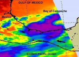
The Atmospheric Infrared Sounder (AIRS) instrument on NASA's Aqua satellite took an infrared image of Tropical Storm Nate on Sept. 7 at 3:59 p.m. EDT, one hour before Nate was named a tropical storm. The infrared data showed the coldest cloud top temperatures (-63 Fahrenheit/-52 Celsius) and strongest thunderstorms with the heaviest rainfall were still off-shore from eastern Mexico and over the Bay of Campeche. On the morning of Sept. 8, the strongest convection (rapidly rising air that forms the thunderstorms that power a tropical cyclone) were mostly in the southwest quadrant of the storm.
Today, Nate is still meandering around in the Bay of Campeche with nothing to guide him, but that will change over the weekend as a ridge (elongated area) of high pressure is expected to develop over Mexico and bring Nate westward.
A tropical storm warning is in effect in Mexico from Chilitepec to Celestun, where 2 to 4 inches of rainfall is expected with isolated amounts as high as 8 inches in the Mexican states of Campeche, Tabasco and southern Veracruz. Tropical storm-force winds are expected today in the warning area. Nate is expected to create a storm surge of 1 to 3 feet above normal tidal levels in the warning area along the immediate coast.
This infrared image of Tropical Storm Nate was captured on Sept. 7 at 3:59 p.m. EDT, one hour before Nate was named a tropical storm. The infrared data shows the coldest cloud top temperatures (purple) and strongest thunderstorms with the heaviest rainfall were still off-shore from eastern Mexico and over the Bay of Campeche. Credit: Credit: NASA JPL, Ed Olsen
At 8 a.m. EDT on Sept. 8, Nate's maximum sustained winds were near 45 mph, and are expected to strengthen in the warm waters of the Bay. Nate was located about 125 miles (200 km) west of Campeche Mexico near 20.2 North and 92.4 West. Nate is creeping to the southeast near 1 mph (2 kmh) and has a minimum central pressure of 1003 millibars.
The TRMM satellite, which is managed by both NASA and the Japanese Space Agency, got a good look at the rainfall rates occurring in Nate yesterday. The Tropical Rainfall Measuring Mission (TRMM) satellite flew over Nate on Sept. 7 at 1812 UTC (2:12 p.m. EDT), a couple of hours before being designated a tropical storm. Data from TRMM's Precipitation Radar (PR) showed that the forming tropical cyclone had areas of heavy convection with cloud tops reaching to heights of about 14km (~8.7 miles) south of Nate's center of circulation. That coincides with the infrared data from NASA's Aqua satellite, which showed the coldest, highest cloud tops in that same area. The strongest rainfall was on the south-southwestern quadrant where rainfall rates were as high as 2 inches (50 mm) per hour.
The forecast from the National Hurricane Center calls for Nate to become a hurricane over the weekend and make landfall in eastern Mexico early next week.
Provided by NASA's Goddard Space Flight Center


